


Categories
- No categories
- more

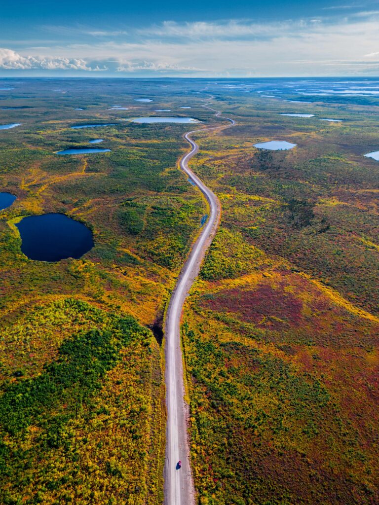
Your trip along the Dempster Highway is going to be filled with many hours where you are the only person for kilometers around, so it’s important to take full advantage of the few stops and services where you can gas up, get some rest, and enjoy a good meal.
Eagle Plains has a population of 8, making it one of the smallest communities in the Yukon. It’s the only hotel and garage between Dawson City and Inuvik, and one of the few places you can meet and chat with people also heading up or down on the Dempster.
Less than an hour from the Arctic Circle sign, Eagle Plains gives plenty of wide and wild opportunities to see the spectacular Northern landscapes and wildlife.

Your journey down the Dempster Highway starts here in the City of Dawson in the Yukon. Dawson City is a historic and adventure-filled destination in its own right – the centre of the Klondike Gold Rush from 1896-1899.
Getting to Dawson City can be an adventure itself before you even start down the Dempster Highway – access Dawson City by road from Whitehorse or even Alaska on a scenic journey on the North Klondike Highway (#2) or the Top of the World Highway (#9). Flying is an option from Whitehorse, Old Crow, and Inuvik – but for a truly historic experience, make your way to Dawson City by canoe, kayak or raft down the Yukon River.
Set off on your great Northern adventure up the Dempster Highway towards the Arctic Circle and the end of the road in Tuktoyaktuk.

Congratulations! You’ve made it to the top of the world. Travellers from all over the globe arrive in Tuktoyaktuk and head to the shore to take a dip in the brisk waters of the Arctic Ocean. It’s a mysterious, life-giving body of water that few get to see with their own eyes, let alone stick their toes in.
The smallest and shallowest (and coldest) of the world’s five major oceans, the Arctic Ocean is nevertheless teeming with life – from ice algae and phytoplankton to dizzying schools of fish and awe-inspiring marine mammals like seals, whales, walruses and polar bears.
Follow the Dempster Highway to Inuvik, and then onward on the Inuvik to Tuktoyaktuk Highway, journeying north as the east channel of the Mackenzie River snakes its way towards the mouth of the Beaufort Sea. You’ll pass the treeline where the boreal forest ends and enter the wide-open tundra of the Barrenlands and the grazing range of Canada’s only herd of domestic reindeer.
The all-season highway, which takes about two-and-a-half hours to drive from Inuvik, ends at the furthest point north someone can reach by car in Canada. Take care on your journey as the highway can be rough in spots and the trip is almost all beyond cell service. Make sure you bring provisions and drive with caution.

If you’ve never visited the Western Arctic before then make sure to start your adventure with a quick stop at the Western Arctic Visitor Centre in Inuvik. It’s your one-stop shop for information related to visiting or traveling through this incredible region.
Located on Mackenzie Road, just as you enter town from the Dempster Highway, the Visitor Centre contains a multitude of fascinating exhibits on local art, flora, fauna, and neighbouring communities. This is also where you can pick up your official Arctic Circle Adventurer Certificate.
The Centre is open from June 1 to September 1 and hosts weekly events based around northern culture. Call 867-777-4727 (or 867-777-7353 during the off-season) or email travel_westernarctic@gov.nt.ca for more information.

Perched on a cliff overlooking the Peel River, tucked in amongst the white birch and spruce trees, Nitaiinlaii Territorial Park is an ideal place to unwind after an epic journey on the Dempster Highway
Though the park is best known as a campground, it’s also a popular picnic day-use area and rest stop. Just inside the entrance is a beautiful log building, cut from Peel River timber, which serves as an interpretive and information centre. It provides travellers information about the local area, exciting adventures to be had and current conditions of the Dempster. The interpretive centre also features historical displays detailing the rich culture and traditions of the Gwich’in people.
Nataiinlaii means “water flowing out in all directions” in the Gwich’in language. The Gwich’in were the first inhabitants of this area and the park is named after the waters here that served as their hunting and fishing grounds, as well as a vital transportation route.
There are 23 non-powered campsites in the park with picnic tables, fire pits and firewood. The site also features washrooms, a kitchen shelter, drinking water and on-site security. There’s no online booking for the camp, but sites are generally available at all times and can be booked upon arrival.
Nataiinlaii is located about 200 kilometres south of Inuvik at the 541 kilometre (Mile 336) point, only 76 kilometres after crossing the Yukon border.

The most northern commercial and community greenhouse in North America, and the largest of its kind in the world, the Inuvik Community Greenhouse provides fresh, local, sustainable produce north of the Arctic Circle.
In the summer, Inuvik gets 24 hours of sunlight, which means produce grows fast. The greenhouse’s 16,000-square feet of space is used by locals who pay a small fee to garden and volunteer their time to maintain the space. There are over 170 garden beds in the greenhouse, with dedicated plots for Elders, group homes, children’s groups, and the local food banks. The greenhouse also contains a commercial space where plants are sold to cover operational costs.
Scheduled tours are available from June through September. Contact the Inuvik Community Greenhouse online to book or purchase gift shop items outside of regular hours.
Opened recently, The Inuvik Greenhouse Cafe’s garden-inspired menu is designed to provide residents and visitors with delicious meals that showcase the greenhouse’s bountiful harvest. The menu changes weekly to incorporate the freshest available ingredients, making each visit a new culinary adventure.
Visitors to the cafe can enjoy a variety of dishes made from locally grown produce, ensuring that each meal is not only fresh but also supports the community’s efforts toward self-sufficiency and sustainable living. The cafe also serves as a community hub, fostering social interactions and promoting healthy eating habits in the region.
Open Wednesdays, 5 p.m.–8 p.m., Thursday–Sunday, 10 a.m.–4 p.m. between June and August. It is also open weekends from 10 a.m. to 4 p.m. in September.